Bengaluru: The Indian Space Research Organistaion (ISRO) on Monday evening released mages captured by its earth imaging and mapping satellite, CARTOSAT-3, showing the damages caused by a series of massive earthquakes that struck Myanmar on March 28. The biggest of them was of magnitude 7.7. As per latest reports, over 2,000 people lost their lives.
The images were captured by the ISRO satellite on March 29. The images showed destruction caused in the cities of Mandalay and Sagaing in Myanmar. The satellite also acquired images before the earthquake.
Additionally, the pre-event Cartosat-3 data acquired on March 18 covering the same area was referred for change analysis and assessment of damage, the space agency said as reported by PTI.
Images captured by ISRO satellite after Myanmar earthquake
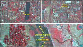
“Significant damage to infrastructure in Mandalay city was observed, with major landmarks such as Sky Villa, Phayani Pagoda, Mahamuni Pagoda and Ananda Pagoda, University of Mandalay and several others suffering either complete or partial damage. In Sagaing city, damage was observed in the Ma Shi Khana Pagoda, along with several monasteries and other buildings,” the ISRO said in a statement.
According to ISRO, as seen from the imagery, the earthquake caused the complete collapse of the historic Ava (InnWa) Bridge on the Irrawaddy River near Inn Wa City. Cracks, and ground ruptures in flood plains of Irrawaddy River with associated liquefaction were also observed.
Images captured by ISRO satellite after Myanmar earthquake
In the statement, the space agency noted that an earthquake of magnitude 7.7 struck Myanmar on March 28 followed by a strong aftershock of magnitude 6.4. The epicentre is located at 22.013° N 95.922° E at a depth of 10 km near the Sagaing-Mandalay border.
Images captured by ISRO satellite after Myanmar earthquake
ISRO further said that the epicentre of the quake was located near Mandalay, Myanmar’s second-largest city, which experienced severe damage. The earthquake also rattled the capital Naypyidaw and other regions, resulting in the collapse of infrastructure, roads and residential buildings.
Images captured by ISRO satellite after Myanmar earthquake
“The tremors were felt not only in Myanmar but also in neighbouring countries. The shockwaves were strong enough to be felt as far as Chiang Mai and northern parts of Thailand, where residents reported damages,” it added.
After the earthquake, Myanmar’s military government declared an emergency in the country. Rescue operations are still underway. Thousands of people were also reportedly injured in the tragedy. Tremors were also felt in Thailand.
Notably, India was the first country to send humanitarian aid to the earthquake-affected country.


